Projects: Louisiana
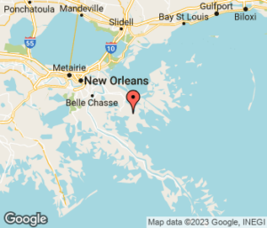
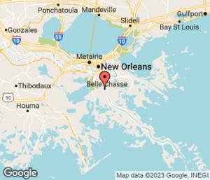
Breton Ridge Restoration: Bayou LaLoutre
- State: Louisiana
- Type: Ridge Restoration
These two projects would restore historic ridges which provide critical habitat for migratory birds and wildlife in Breton Sound where wetlands are rapidly disappearing. Both projects are located east of the Mississippi River in the Breton-Chandeleur Basin. The Bayou Terre aux Boeufs ridge stretches from the community of Delacroix to Black Bay and the Bayou la Loutre Ridge extends from the community of Yscloskey into the southeastern Biloxi marshes. Restoration of these ridges will raise the ridge height, providing coastal upland habitat, increasing storm surge protection for nearby communities and helping restore the natural flow of water in the basin. Status: Conceptual
Fish and Waterfowl Benefits
Rising sea levels, subsidence and storms have eroded the ridges in Breton Sound. Restoration of these ridges will help maintain the health, stability and function of the existing Breton Sound wetlands. These wetlands provide nursery and foraging habitat to a variety of fish and waterfowl and other wildlife.
Project Status:
- Conceptual
- Feasibility & Planning
- Engineering & Design
- Under Construction
- Completed
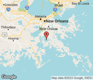
Breton Ridge Restoration: Bayou Terre aux Boeufs
- State: Louisiana
- Type: Ridge Restoration
These two projects would restore historic ridges which provide critical habitat for migratory birds and wildlife in Breton Sound where wetlands are rapidly disappearing. Both projects are located east of the Mississippi River in the Breton-Chandeleur Basin. The Bayou Terre aux Boeufs ridge stretches from the community of Delacroix to Black Bay and the Bayou la Loutre Ridge extends from the community of Yscloskey into the southeastern Biloxi marshes. Restoration of these ridges will raise the ridge height, providing coastal upland habitat, increasing storm surge protection for nearby communities and helping restore the natural flow of water in the basin. Status: Conceptual
Fish and Waterfowl Benefits
Rising sea levels, subsidence and storms have eroded the ridges in Breton Sound. Restoration of these ridges will help maintain the health, stability and function of the existing Breton Sound wetlands. These wetlands provide nursery and foraging habitat to a variety of fish and waterfowl and other wildlife.
Project Status:
- Conceptual
- Feasibility & Planning
- Engineering & Design
- Under Construction
- Completed
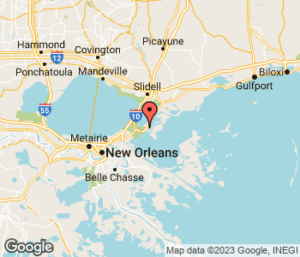
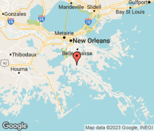
New Orleans East Landbridge Restoration
- State: Louisiana
- Type: Marsh Restoration
This marsh creation project is located in eastern New Orleans on the narrow landbridge that separates Lake Pontchartrain from Lake Borgne. Salinities have increased in this area due to local subsidence and canals and along with waves, have resulted in the rapid retreat of the shoreline and expansion of ponds and lakes within the marsh. This project will create and restore this marsh land-bridge using sediment, restoring significant fish and wildlife habitat and a crucial line of defense from storm surge for 1.5 million people in the parishes surrounding Lake Pontchartrain.
Fish and Waterfowl Benefits
This project is a critical landscape feature that includes the Bayou Sauvage National Wildlife Refuge, the largest urban refuge in the nation. The refuge provides opportunities for sportsmen to fish and crab and for youth to hunt waterfowl. The landbridge also helps buffer storm surge for the nearby Big Branch National Wildlife Refuge where people crab, hunt deer, small game and waterfowl, and fish in the marshes, bayous and in Lake Pontchartrain for speckled trout, bass, redfish and other popular species.
Project Status:
- Conceptual
- Feasibility & Planning
- Engineering & Design
- Under Construction
- Completed
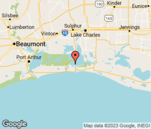
Calcasieu Ship Channel Salinity Control Measures
- State: Louisiana
- Type: Hydrologic Restoration
The Calcasieu Ship Channel, which connects the Gulf of Mexico to Calcasieu Lake, located in the Chenier Plain. Once a stable, the Chenier Plain has undergone decades of dredging to build navigation canals, which has dramatically changed the flow of water in the area. Saltwater intrusion has led to the extensive loss of freshwater marshes and increased the threat of storm surge to nearby communities. This project will build a network of dike and sill structures designed to limit saltwater intrusion from the Calcasieu Ship Channel into nearby marshes that provide habitat to fish and wildlife and a storm surge buffer to communities.
Fish and Wildlife Benefits
By helping sustain nearby wetlands, this project will benefit the wetlands of this region which provide important habitat to the area’s wildlife. The areas that benefit from this project include the Sabine National Wildlife Refuge and the Cameron Prairie National Wildlife Refuge which provide a variety of recreational opportunities to sportsmen, such as fishing, crabbing, and hunting waterfowl and alligator.
Project Status:
- Conceptual
- Feasibility & Planning
- Engineering & Design
- Under Construction
- Completed
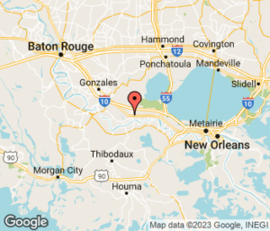
River Reintroduction into Maurepas Swamp
- State: Louisiana
- Type: Sediment Diversion
Also known as Mississippi River Reintroduction into Maurepas Swamp, this diversion project, near Garyville, Louisiana will channel fresh water and some sediment from the river to benefit the eastern Maurepas swamp. Dominated by bald cypress and water tupelo trees, this swamp is one of the largest forested wetlands in the nation. However, levees constructed along the river and the closure of Bayou Manchac have isolated the area from spring floods that once provided vital fresh water, nutrients and sediment. This along with higher salinities that were throughout the Pontchartrain Basin before the closure of the Mississippi River-Gulf Outlet has left the swamp in a state of rapid decline – trees are dying, and young trees are not growing to replace them. The East Maurepas Diversion will benefit the swamp by reconnecting it with the river, preventing further loss and the conversion to open water, and push back against future increases in salinity due to sea level rise. .
Fish and Waterfowl Benefits
Increased fresh water and nutrient input in the Maurepas Swamp will help prevent further conversion of swamp to open water and combat saltwater intrusion into the more than 100,000 acre Maurepas Swamp Wildlife Management Area which offers opportunities for sportsmen to hunt white-tailed deer, ducks and alligator and fish for freshwater species, such as largemouth bass, sunfish, and crappie.
Latest News: $14.2 million awarded to design, engineer Maurepas Swamp diversion project
Project Status:
- Conceptual
- Feasibility & Planning
- Engineering & Design
- Under Construction
- Completed
Increase Atchafalaya Flow into Terrebonne Marshes

- State: Louisiana
- Type: Hydrologic Restoration
This freshwater diversion project stretches from the Atchafalaya River to the Houma Navigation Canal, which is part of the Gulf Intracoastal Waterway system. Terrebonne Basin marshes are equally far away from the Mississippi and Atchafalaya rivers and are blocked from significant amounts of river water and sediment. As a result of saltwater intrusion and sediment starvation, these marshes have been rapidly converted to open water. This project would dredge and deepen the Gulf Intracoastal Waterway to increase the flow of fresh water from the Atchafalaya River eastward, to help sustain northern Terrebonne Marshes.
Fish and Waterfowl Benefits
Over the last 50 years, while there’s been net land gain around the Atchafalaya River and Wax Lake Outlet, more than 250,000 acres of land have been lost in Terrebonne Bay. This project will increase freshwater input into northern Terrebonne marshes to sustain and protect freshwater marshes, benefitting important habitat for fish and wildlife, like the Mandalay National Wildlife Refuge where sportsman can crab, fish, hunt waterfowl, hogs and white-tailed deer.
Project Status:
- Conceptual
- Feasibility & Planning
- Engineering & Design
- Under Construction
- Completed
Mid-Breton Sediment Diversion
- State: Louisiana
- Type: Sediment Diversion
This project will be located along the east bank of the river, near White Ditch, Louisiana. This sediment diversion will supply fresh water and sediment into deteriorating marshes of the Breton Sound Basin. The wetlands in the project’s influence area have disappeared due to changes in the supply and distribution of fresh water, sediment starvation, rapid subsidence, saltwater intrusion and storm events. This project will reconnect the wetlands in the mid-Breton Basin with the river, diverting sediment and fresh water to build new land and sustain existing marsh.
Fish and Waterfowl Benefits
This project will build, enhance, sustain and protect wetlands in the mid-Breton Basin. The project will also help restore and maintain the estuarine gradient (fresh water habitat in the upper basin to salt water closer to the Gulf) that is vital to the estuary’s fish, blue crabs, and waterfowl, other species and recreational fish species in the Gulf.
Project Status:
- Conceptual
- Feasibility & Planning
- Engineering & Design
- Under Construction
- Completed
Large-Scale Barataria Marsh Creation
- State: Louisiana
- Type: Marsh Restoration
This marsh creation project is in Mid-Barataria Basin in the vicinity of the town of Lafitte. Historically, there was a limited connection between the fresher upper basin and the saltier lower basin. Canal networks, erosion and subsidence have eaten holes through the natural barriers, exposing wetlands in the upper basin to saltwater intrusion and waves. A critical landscape feature, this project will continue to build on marsh creation projects that have been constructed or are under construction to strengthen the Barataria Landbridge. Sediment conveyed from the river through a pipeline will be used to build new marsh, nourish existing marsh in the area, help restore historic low salinities in the upper basin and help protect the nearby community of Lafitte from storm surge and tidal flooding.
Fish and Waterfowl Benefits
Restoration and renourishment of the Barataria Land-Bridge will help protect the 30,000 acre Salvador/Timken Wildlife Management Area and Jean Lafitte National Historic Park and Preserve, located in the upper part of the Barataria Basin, from the devastating effects of saltwater intrusion and damage from storms. Both of these areas provide freshwater habitat to waterfowl, deer, bass, catfish and other species and recreational opportunities to sportsman.
Project Status:
- Conceptual
- Feasibility & Planning
- Engineering & Design
- Under Construction
- Completed
Mid-Barataria Sediment Diversion
- State: Louisiana
- Type: Sediment Diversion
This sediment diversion project is located on the west bank of the river, near Myrtle Grove. The brackish and freshwater wetlands in the area are highly degraded due to saltwater intrusion, decreased fresh water supply, alterations to the natural flow of water in the area and a lack of sediment input. This project will reconnect the river to the Barataria Basin and divert sediment and fresh water to build new land, maintain existing marshes and increase habitat’s ability to persist in the face of rising sea levels and recover from storm events.
Fish and Waterfowl Benefits
By building new land and helping to sustain the existing wetlands, this project will restore and enhance critical habitat for fish, ducks and other wildlife in mid-Barataria Basin. This project will also help to sustain the Barataria Landbridge which protects freshwater habitat in the upper part of the basin that provide recreational opportunities for sportsman, including the 30,000 acre Salvador/Timken Wildlife Management Area and the 20,000 acre Jean Lafitte National Historic Park and Preserve, from the saltwater intrusion and storms.
Project Status:
- Conceptual
- Feasibility & Planning
- Engineering & Design
- Under Construction
- Completed